In BS. Yet another attempt to oversell the reasons for and danger of sea-level rise in the Chesapeake Bay.
Climate, environmental change hit close to home for Tangier, Indian tribes
Climate change commands global attention, but its effects are falling fast and hard on one tiny island in the Chesapeake Bay.
Tangier Island has been inhabited by European settlers and their descendants since the 1600s, but a rising sea, erosion and subsidence all threaten to displace its current residents, rendering them the country's first climate refugees.
Let me start with the usual graph of actual sea level rise in Chesapeake Bay, as measured at Baltimore, the longest record in the area:
3.14 millimeters a year, plus or minus a little, with no hint of acceleration due to CO2 induced climate change in the later half of the 20th century. That's about the thickness of a nickel a year. That includes components from the increasing volume of water in the ocean from various sources (mostly ice melt) and subsidence from the effects of glacial rebound further north.
"The island is actually sinking slowly," Quinn Monette, a junior at the College of William and Mary, said Wednesday. "A study by the U.S. Army Corps of Engineers fairly recently projected the island would be completely underwater within the next 50 to 100 years if nothing is done to mitigate it."
 |
| Tangier Island, Virginia |
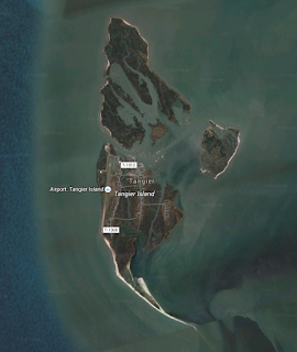
Let's take a look at
Tangier Island, courtesy of Google Earth. Note that the island is already more water than land, and has been for a fair while. Its mostly a large salt marsh, with tidal creeks allowing water to flow into the interior on high tides and drain it on the low tides. On the Bay side (the left) the island has some beaches, but starting along the west side there is an airport, protected by rip-rap walls. Parts of the island are covered with roads and houses, but actually very little of it.
Salt marsh is capable of rising with sea level at moderate rates. Grass grows up catches suspended sediment, dies, and forms a layer of dead grass and sediment on the surface in fall. Slowly, these get buried and turned to peat, and the land rises to match sea level. Faster sea level rise merely encourages the grass to grow faster.
 |
| Eastern shore island showing sod or peat bank |
Chesapeake Bay islands die not through drowning (although I imagine it is, and always has been distressing to live on one during a hurricane), but rather from erosion at the edges. While the surface make grow up, the edges of the peat banks have no way to grow out, and they shrink at the edges. Beaches, on the other hand, can grow upwards, as waves and then wind deposit sands up higher, and get blown into dunes. They do, however, tend to shift around, and make lousy house sites.
Calling the Tangier Islanders "the country's first climate refugees" is, of course, crap. They're being slowly ousted by the same forces that pushed countless
redskins,
Indian,
Native American, Aboriginal people out of the whole interior of Chesapeake Bay, as it flooded over the past 14,000 years, as well as the former post colonial inhabitants of
James, Holland, and
Sharp's Island to name only a few.


No comments:
Post a Comment