With Alison's Adventures:

Bay Journal, Study highlights resistance to ‘retreat’ in face of rising water. Not a terrible article on the choice facing the inhabitants of Smith Island, although it has a "Gorillas in the Mist" feel.
With Alison's Adventures:
We're Still hashing over the week's events. Nick Arama at RedState wants you to Watch: Things Getting Wild in MN As Anti-ICE Crew Harasses Regular People, Concerning City Email Revealed and sees What Led Up to This ICE Operation at a Mexican Restaurant in MN Has the Left Melting Down. Matt Vespa at TownHall, What ICE Agents Did After Eating Lunch at a Mexican Restaurant in MN Will Probably Drive Libs Insane. Came back later for the illegals working there. And Wait, That's How a Local Minnesota Dem Described the Leftist Violence Against ICE "State Sen. Bobby Joe Champion, said attacks on law enforcement following the shooting death of Renee Nicole Good, 37, on January 7 only show that Minnesotans are being good neighbors, or something. This comes after ICE agents were ambushed by Venezuelan illegals this week, some of whom were armed with shovels." Driscoll at Insty, DAVID BROOKS DESCRIBES ICE IN MINNEAPOLIS AS ALMOST AN ‘ARMED OCCUPATION:’ Coddled Affluent Professional @feelsdesperate, "Does the median lib understand this? If state and local authorities in Minnesota cooperated in handing over CONVICTED CRIMINALS to the feds none of what’s happening would be necessary." Quote captive dreamer @captive_dreamer "When ICE shows up in Texas, they go to the local jail and take these people into custody. When they arrive in Minneapolis, they've got to go door knocking because the local police have been told to not cooperate with feds." CIS, Minneapolis School Officials Are Shielding Illegal Aliens from ICE ... and Opening Themselves Up to Federal Felony Prosecutions.
Ben Smith at LI, DOJ Subpoenas Walz, Frey Over Alleged ICE Obstruction and Reckless Rhetoric. ‘Mayor Frey and Governor Walz have to get their city under control. They are encouraging impeding and assault against our law enforcement..” Erick Florack at PJM explains The Reason Walz Is Declaring War on the Federal Government "He’s, in fact, trying to start a civil war, in an effort to protect himself from the consequences of the laws he’s already broken. Mind, this has nothing to do with Renee Good, or anyone else. It’s all about Walz trying to stay both in office and out of jail." Matt Vespa, Here's What a CNN Host Said About Tim Walz That Left Scott Jennings Stunned. "JENNINGS: “They have literally both said ICE leave Minnesota. In fact, Tim Walz said, we’re on the third day of Gettysburg at one point.” PHILLIP: “He did not say that either. Okay, sorry, but he didn’t say that.”" Yes he did. From Twitchy, Tiffany Cross Accuses Pete Seat of Lying About CNN's MN Report — Then the Clip Plays and Exposes Her. Thomas Hern @ThomasMHern, "Why does CNN keep inviting Tiffany Cross back on their network to lie? Pete Seat accurately references CNN's 4PM report on Minneapolis agitators. Tiffany Cross flips out and falsely accuses Pete Seat of misrepresenting the report and being in a cult, Abby Phillips does nothing. Watch the exchange with the 4pm report included and decide for yourself who is lying." Driscoll, “IS THE NEW YORK TIMES A LIBERAL NEWSPAPER? OF COURSE IT IS:” "The Same New York Times That Called Trump a ‘Nazi’ and ‘Fascist’ Objects to THIS Hateful Word for Women. As the article piously reported: In the days since a federal agent killed Renee Good in Minneapolis, Republican officials and conservative commentators have called the 37-year-old white woman “very violent,” a “deranged lunatic woman” and a “domestic terrorist.” Some right-wing influencers have latched onto a different word — or rather an acronym: Ms. Good, they have said, was AWFUL." From Dan McCarthy at RCP, The Trouble With Activism That Abets Law-Breaking. At NYPo the Cherkaskys opine The ICE uproar is a conspiracy calculated to fool Americans "Ordinary Americans are being played — manipulated into dangerous confrontations by politicians and rabble-rousing activists." A video at Hat Hair, Can President Trump Make Minneapolis Great Again? It's doubtful.
Derek Hunt at TownHall asks Why the Hell Should We Care If Democrats Don’t? "I used to feel bad for people in the cities overrun by Democrats’ BLM/ANTIFA Brownshirts; who wants to see their fellow Americans going through hell? But then you realize that these people voted for this, and did so repeatedly. I can have sympathy for someone complaining of a headache, but it quickly fades if I find out they have a habit of hitting themselves in the head with a frying pan. After that, I stop caring completely. We’re too that point with everything Democrats do." From the Chicago Boyz, The Fire Next Time. "It doesn’t take much imagination to conclude that what happened to the J6 protestors would land on any military or law enforcement personnel luckless enough to catch the focused attention and malice of progressives to headlines to brandish and solitary prison cells to fill. The veniality and vengefulness of our current crop of ambitious progressive politicians and administrators guarantees that they would not be able to resist the opportunity to grandstand."
Each Republican is always more Hitler than the previous one. Driscoll, SOCIALISTS NATIONALLY BEGIN SEARCHING FOR THEIR NEXT HITLER: Jim Acosta Helps Dems Make the Pivot to ‘JD Vance Is Worse Than Trump’ (Plus: Get the TDS Straitjacket!). Curtis Houck@CurtisHouck, "Jim Acosta: “[JD Vance is] the future of MAGA. It is a — a — it is a fascist, authoritarian, white nationalist MAGA.” Jennifer Welch: “It’s worse than Trump.” Acosta: “It is worse than Trump.” Welch: “He’s worse.” Acosta: “It’s Trump with staying power. You know, Trump, the other day is, you know, he’s — he’s — he’s asking, am I gonna go to heaven? Am I gonna go to heaven?” Welch: “Yeah.” Acosta: “It must be dawning on him that the sand in — in Dorothy’s hourglass is running out, you know, in the Wizard of Oz.” Welch: “The curtains are closing. . . ”" Sunny @sunnyright, "Fascism is when Donald Trump enforces laws that Barack Obama enforced, but with the key distinction that Democrats are big mad about losing the election and so that makes it fascism."
At Breitbart, Trump Cancels Biden Rules Forcing Banks to Give Loans to Illegals. What a fascist!
From the Chronic, Trump’s Successes All Point to Avoiding Entanglements. Josh Hammer at Hat Hair wonders Is a Red Line Still a Red Line? in Iran. No Pasaran! claims a Bombshell Revelation! Lexington Institute Explains the Exact Event Which Caused Trump 45 to Want to Acquire Greenland; ADDENDUM: Here Is What Is Wrong with Greenland's Status Quo, "it turns out that in 2017, according to the Lexington Institute's Rebecca Grant, Greenland’s prime minister flew to Beijing and asked China to bankroll new airports, according to The Wall Street Journal. [To its credit,] Denmark stopped the deal. If anything like that happens again, Greenland will be flying a U.S. flag." Tim O'Brien at PJM revisits Denmark’s Dirty Little Secret About Population Control in Greenland. Involuntary sterilizations. Sundance at CTH admires how President Trump Announces New Tariffs Against “EU Leadership” Nations Attempting to Interfere in North American Strategic Defense and Greenland Negotiations. Matt Taibbi at Racket asks If NATO Dies, Do We Really Have to Mourn? "Donald Trump's Greenland-gobbling may mean the end of the Atlanticist dream, which should have ended with the fall of communism."
From Da Signal, Hegseth Declares War on Pentagon Bureaucracy
Stacy McCain has a Radical Vegan Transgender Cult Update: Three ‘Zizians’ Make Court Appearance, in western Maryland.
Betsy Stauffer at LI, Virginia Democrats Vote to Redraw Congressional Map, Target Four-Seat Gain, "The Virginia state Senate passed a constitutional amendment on Friday that, if approved by a statewide referendum, would allow the Democrat-controlled legislature to redraw the state’s congressional maps before voters head to the polls this fall. This move could hand the Democrats four new seats in Congress. The Commonwealth is divided into 11 congressional districts. Democrats currently hold six of those seats, and the GOP, five. If the Democrats’ redistricting efforts are successful, that balance would be transformed into a 10–1 supermajority, all but erasing Republican representation." That would make them worse than Maryland.
Victory Girls envy Kamala Harris’s turn as Marie Antoinette "Former vice president Kamala Harris and her husband Doug Emhoff purchased an $8 million mansion in an exclusive oceanside Malibu neighborhood last month. The move came after Harris spent years warning that such communities could be threatened by the “climate crisis.” A real estate listing for the mansion, reviewed by the Washington Free Beacon, says the luxury pad is “perched in a prime coastal location” with “breathtaking ocean views.” The property sits right near a coastline that—according to climate scenarios endorsed by Harris—is at risk of facing extreme flooding. A climate model issued by the Biden-Harris administration determined that Point Dume State Beach, the beach a short walk from Harris’s new property, would be severely damaged by sea level rise even under the model’s most modest projections." So they'll have a nice cliffside view of the rising seas?
From NYPo, House, feds probe to unravel mystery of ‘Squad’ Rep. Ilhan Omar’s skyrocketing wealth: ‘It’s not possible’ I wonder how many 'day cares' or 'transportation services' she is co-owner of.
At Twitchy, Video of BBC Reporter Trying to Lecture Elon Musk About 'Misinformation' Has Aged WONDERFULLY. RCP wonders If Britain Bans X, How Far Will It Go To Block Free Speech?
TCW, DEI and a stark admission – it’s a war against straight white males.
The Wombat has FMJRA 2.0: Too Good To Be True? marinated and ready for consumption at The Other McCain.
I hope so. WHRO, Proposed revision to Chesapeake Bay agreement cuts out climate change, environmentalists say
The massive, decades-long effort to restore the Chesapeake Bay is at an inflection point. Significant progress has been made, including restoring oyster habitat across the region. Other goals have proven more difficult to achieve, such as cutting pollution.
Growing challenges from climate change now threaten to stall or reverse progress — and local environmental groups worry that proposed changes to the document guiding the bay restoration do not address those threats. “We are glossing over this giant problem that's going to make the bay agreements today and of the future really, really difficult,” said Mary-Carson Stiff, executive director of the Norfolk nonprofit Wetlands Watch.
The concerns stem from the recent release of a draft new iteration of the Chesapeake Bay Watershed Agreement. Virginia and other states around the region signed onto the most recent agreement in 2014. It set 31 benchmarks for participants to voluntarily achieve by 2025, such as boosting seagrass and crab populations. Officials failed to meet about a third of the targets by this year’s deadline.
Late last year, the Chesapeake Executive Council, which includes Gov. Glenn Youngkin and sets the strategic vision for the restoration, launched an effort to formally revise the document by the end of 2025. The resulting draft was developed by a Chesapeake Bay Program committee made up of nearly three dozen members from various state and federal agencies. The draft document simplifies goals, consolidating the previous 10 goals and 31 specific outcomes into four broader goals and 21 outcomes.
The agreement “acknowledges that the partnership cannot address every issue at once and that progress must be made in a strategic manner, focusing on efforts that will achieve the most meaningful and cost-effective results,” officials wrote in the draft.
The 2014 agreement included climate resiliency as a goal and set objectives, including monitoring shifting sea level conditions in the bay ecosystem. The new draft does not mention climate change or sea level rise by name, Stiff said.
“All of a sudden, they change tune and use politically palatable language like ‘changing conditions,’” she said. “To not really speak truthfully about what the challenges are, it does a disservice to everyone who's a part of the hard work to actually implement the goals. The time is now to be radical.”
The Bay restoration project is to find ways to improve the condition of the Bay. Even assuming climate change is significantly changing the Bay, the question is whether that would be for the better or worse. There are plenty of fine, clean ecosystems south of the Bay. Besides, what are you, the Bay folks going to do to fix the climate, ban coal and oil in China and India?

Global sea levels have not continued to rise at the rates predicted by many scientists — and there is no evidence that climate change has contributed to any such acceleration, a new first-of-its-kind study has claimed.
The research found that the average sea level rise in 2020 was only around 1.5mm per year, or 6 inches per century, according to the paper’s authors, Dutch engineering consultant Hessel Voortman and independent researcher Rob de Vos.
“This is significantly lower than the 3 to 4 mm/year often reported by climate scientists in scientific literature and the media,” Voortman told independent journalist Michael Shellenberger.

Voortman was shocked that no researcher before had performed an analysis of real-world local data.
The study was also unlike any of its kind in that it was carried out with no external funding, said Voortman, who has spent the last 30 years as a hydraulic engineer working with flood protection and coastal-infrastructure adaptation projects around the world.
In 2023, Voortman published a bombshell paper claiming that sea level rise across the low-lying Dutch coast hadn’t accelerated.
 |
| It's getting deeper! |
“From practice, I had already encountered the situation that sea level projections were exceeding sea level observations,” he said.
He decided to put his theory to the test worldwide, looking at 200 different tide-gauge stations with at least 60 years of data to study.
“For the vast majority of the stations, the differences between the two curves were not significant,” Voortman said, adding that this indicated no detectable acceleration in sea level rises.
The data is widely available, and though I haven't searched for it, I think I recall a post by Willis Eisenbach at WUWT that did just that, and came up with the same answer. I like to pull out the long tidal gauge record from Baltimore:

I know, 3.2mm is more than the world average of 1.5 mm, but subsidence in the mid Atlantic region is well established.
Bay Journal, FEMA cancels $1 billion for flood prevention projects in Chesapeake Bay region
As Crisfield Mayor Darlene Taylor sees it, the low-lying Maryland town has no future unless it can hold back rising water. Computer models suggest that the adjacent Chesapeake Bay could get high enough by 2050 to trigger daily floods that are deep enough to stall cars on roads.
"Could" is doing some heavy lifting here. At the current rate of sea level rise/ground subsidence of about 3 mm per year, which shows no sign of increasing, it should be a long time before the water reaches the engines of cars. But they always reference the wildest, least realistic estimates of future sea level rise.
Hope arrived in the form of a federal grant program under the Federal Emergency Management Agency, created during the first Trump administration. The Building Resilient Infrastructure and Communities (BRIC) program helped rural communities like hers to invest in massive projects to fight disaster threats, ranging from wildfires to floods.
Crisfield officially got word from FEMA last July that it had secured $36 million from the program to launch the first phase of its massive flood-protection initiative. “Everything had lined up and everything was in place for this to be a highly successful project,” Taylor said.
A lot has changed since then. Trump returned to office in January, vowing to drastically shrink the size of the federal government. In a terse April 4 press statement, FEMA announced it was pulling the plug on the disaster-preparedness funding, not just for Crisfield but for all applicants and grantees, calling it “wasteful and ineffective,” though without citing evidence to support those claims.
The administration announced that any undistributed funds from the program’s inaugural year, 2020, through 2023 would be returned to the Disaster Relief Fund or the U.S. Treasury. The agency also canceled the 2024 funding opportunity, just days before the application deadline for that year’s $750 million allocation.
If Crisfield want's to stay where it is, maybe they should look into what it would take to prepare for floods.
At the Capital Gazette, Maryland lawmakers fear deep EPA cuts could cripple Chesapeake Bay restoration
Maryland lawmakers are waiting warily for an Environmental Protection Agency budget that they fear could cut staff so deeply that the Chesapeake Bay restoration program could not adequately proceed. The full budget release, expected in the coming weeks, will follow the agency’s “skinny budget”—essentially a broad budget outline — unveiled in early May and proposed cutting more than half of the agency’s $9.1 billion budget. The Trump administration’s EPA budget request for the 2026 federal fiscal year, which begins Oct. 1, was for $4.2 billion.
“I don’t know how we actually implement the Bay program — even it’s fully funded, which I have no reason to believe it will be when we get the final details — when we’ve taken a chainsaw to staffing,” Rep. Sarah Elfreth, a Maryland Democrat, said in an interview Tuesday.
EPA Administrator Lee Zeldin told Maryland Sen. Chris Van Hollen during a Senate Appropriations hearing last week that he supported the bay program, which is currently funded at $92 million a year. “The Chesapeake Bay Program is an amazing program. Our team takes great pride in running it,” Zeldin said in response to Van Hollen’s questions.
There's no government program that couldn't benefit from a 20% cut, some much more, and some should be eliminated entirely.

We are getting our first look at the city of Norfolk’s flood protection plan—a plan that includes a 16.5-foot-high wall along the waterfront at a cost of a couple of billion dollars.
Norfolk officials released updated designs for the first section of the city’s Coastal Storm Risk Management Project. The project aims to protect Norfolk from major flooding events such as hurricanes. The new designs shows how a combination of walls and levees and floodgates will protect areas around Harbor Park and Waterside from high water. The entire project is expected to cost $2.6 billion.

Norfolk was established along the Elizabeth River for its commerce routes. But being so close to the river put the city in the path of floods, too. According to Norfolk leaders, a hurricane in 1749 pushed waters up to 15 or 16 feet above normal. This storm, and another in 1806, created Willoughby Spit. Two hurricanes in 1933 provided enough flooding for children to swim in the downtown streets. (We don’t recommend swimming in floodwaters!) Hurricane Isabel, in 2003, brought a storm surge of about 5 feet, which was still high enough to flood large parts of the city.
Norfolk has taken the lead in preparing for coastal flooding, especially compared to other large East Coast cities like New York and Charleston, South Carolina. But designing flood protection is complicated. In addition to the engineering and cost challenges, there is the character of the waterfront itself. Businesses and people inhabit the shorelines for access to the water or to enjoy its views. Flood barriers can cut the city off from the very river that gives it life.
The new plan offers a variety of components to address the flooding while maintaining access and views as much as possible. It shows structures such as T-walls, Bin-walls, gates, and pump stations, along with natural components such as living shorelines and oyster restoration projects. The system is designed to be 16.5 feet tall, which designers believe will protect Norfolk from a 70-year storm surge in the year 2076.

The Elizabeth River Trail, which follows Norfolk’s shoreline downtown, will be elevated to the top of the wall in some areas, so trail visitors will still be able to enjoy the views and breezes. However, in some areas raising the trail is not practical, and there will be sections where hikers will walk along a wall that restricts their views. While some residents have complained, there may not be much choice.This illustration shows how parts of the wall would block the city from views or access to the river it is built along.Another illustration shows how the floodwall would protect from high water, but still allow some visibility along parts of the waterfront from an elevated Elizabeth River Trail.
According to Norfolk’s Lori Couch, “During the feasibility study that was completed in 2019, we evaluated various alternatives for the project and the floodwall for this part of the city scored the highest Benefit/Cost Ratio. For example, we evaluated a do-nothing option, a non-structural option, and a combination of both for all the watersheds in the city.”

At WUWT, Wrong, Oregon Public Broadcasting, Oregonians Are Not Being “Hit Hard” By Climate Change
A recent article posted by Oregon Public Broadcasting (OPB), titled “Climate change will keep hitting Oregonians hard, but the exact impact will depend on where you live,” claims that Oregon will be impacted severely on multiple fronts by climate change. Areas of concern include increased wildfires, sea level rise, and water shortages, among others. This is mostly false, as many of the problems listed are not worsening and those that are have nothing to do with climate change.
OPB writes that different regions of Oregon will face different effects from climate change, which is reasonable; coastal communities will have to worry about sea level more than those in Eastern Oregon, for example. But the caveats listed by OPB are interesting. The story doesn’t just discuss geographic and natural climate differences, but also differing effects based on demographics, such as, “how many people live there, and how much money their local governments have on hand.” Those two variables, and others like population growth and relative incomes, are totally independent of long-term climate change and even short-term weather events.
Regardless, the article goes on to make several false claims regarding the direct effects of climate change:“The Oregon Coast faces sea-level rise, algal blooms and shellfish biotoxins. The northern Willamette Valley faces heat waves, higher landslide risks and increased water demands as the population grows. Northeastern Oregon faces longer fire seasons, scorched crops and increasing numbers of destructive pests.”For the sake of brevity, we will not go into each in assertion made in this post, but almost every one of these supposed hazards are overblown at best, and or simply not occurring, at worst.
Beginning with sea level rise, the average absolute sea level rise globally is about 1.7+/-0.3 millimeters per year. Two out of the five available National Oceanic and Atmospheric Administration (NOAA) sea level monitoring stations in Oregon are slightly above that rate, at 1.78 +/- 0.58 and 2.52 +/- 0.61 mm/year or The rest are below the average global rate. These rates equate to a rise of about 0.58 ft and 0.83 ft over the course of 100 years, respectively
Monitoring stations at Port Orford and Astoria both show negative sea level rise, which means land is likely rising faster than absolute sea levels, making a net drop in relative sea level. . . .
OMG, in a few thousand years, Port Orford and Astoria will be inland, cut off from the Pacific! If the Cascadia Fault doesn't wipe them out first...
And warmer weather? Too bad the Californians who moved to Oregon for the cooler weather will have to move on the Washington state.

Annapolis has already installed a pump system which is helping keep the city dock dry during minor flood tides. For several years, Buckley has been moving ahead with a nearly $100 million plan to make the Annapolis waterfront more resilient.
“We’re going to raise city dock 6’we’re going to make a park instead of a parking lot. In the middle of that park is going to be a beautiful fountain, but that park is actually the barrier against sea level rise. So, this city dock will no longer flood," he said.
He is facing a current of opposition from historic preservationists and is still lobbying for more federal funding to get it done; in recent weeks he created a tiny beach in a parking lot to make the point the water is rising. He also flies a “Don’t give up the dock” flag, a play on the Navy's “Don’t give up the ship” slogan.


For more than 20 years, Malagón has been coming to work in crab processing plants on Hoopers Island, one of the many island communities in the Chesapeake Bay.
Hoopers Island, a chain of small islands linked by causeways, has been the center of the state’s seafood industry since the early 1900s. Due to its low-lying nature, the region has faced erosion and destructive storms over the years.
But rising sea levels are increasing the frequency of flooding, creating uncertainty for the village’s watermen and their families, who have long depended on the seafood industry for their livelihoods. The situation is especially worrying for female migrants such as Malagón, who have limited job prospects back home in Mexico and wonder how long they will be able to work on the island.
Historically, a cadre of largely black women living on the Eastern Shore picked crab. However, in recent years (meaning the last 20 or so), the black women have been largely replaced by illegal immigrants who come to the region for crab season, and leave when it is over. What happened to the black women who used to pick the crab? Well, in particular cases it's anybody's guess, but in a general sense, rising welfare payments (along with the aspects of welfare that discourage marriage) has probably encouraged them to move elsewhere, Hoopers Island not having an exactly riveting night life. I suspect many have moved to Baltimore and PG County in search of better paying, and less messy jobs.


Nearly 100 years after it was first established, the Fox Island lodge and former education center between the Tangier and Pocomoke Sounds of the Chesapeake Bay has reportedly burned down. The island where the center was located sits just south of the Maryland-Virginia border off the Cedar Island State Wildlife Management Area south of Crisfield.
Frank Pruitt, Crisfield Fire Department Chief, tells WBOC the building has burned down but no local fire departments were alerted Friday night. Crisfield has the closest fire boat in the area, according to Pruitt. “It’s very surprising,” Pruitt said.
The center first began as a hunting lodge in 1929. The Chesapeake Bay Foundation took ownership of the island and launched the Chesapeake Bay Foundation Fox Island Education Center in 1978.
But the island and the Education Center would face a losing battle with rising waters in the Chesapeake. The Foundation bid farewell to the building in 2019 and ceased operations there, saying it would inevitably become unsafe conducting their education program at the Fox Island Center due to sea level rise and erosion. More than 70 percent of the island’s land area had washed away in the past 50 years the CBF said in their blog post in 2019.
“It’s hard to imagine CBF without it—Fox was our first residential education center,” the Chesapeake Bay Foundation said at the time.
The cause of the fire is currently unclear.
A Facebook video shows the center burning.
 |
Salt patches on a farm in Somerset County, MD, are visible as bare white streaks along the edges of cropland. |
Climate change is claiming farmland at “an alarmingly high rate” in one of the Mid-Atlantic’s most productive agricultural regions, inflicting tens of millions of dollars in economic damage, a team of scientists says in a new study.
Their research spotlights a pernicious side effect of sea level rise: the salt left behind from water washed onto land after storms or unusually high tides. The resulting “salt patches,” supercharged by evaporation, can poison large swaths of cropland, reducing yields and farm profits.
From 2011 to 2017, the amount of Delmarva Peninsula farmland that converted into salt patches nearly doubled to more than 2,200 acres, the study estimates. That translates into as much as $107 million in annual crop losses in the region, the researchers say.
“Saltwater intrusion is far more extensive than I think we originally anticipated,” said Kate Tully, an agroecologist at the University of Maryland and one of the study’s authors. “There is an important need for us to come up with a suite of solutions for farmers and landowners on the Eastern Shore.”
The study, published by the journal Nature Sustainability in July, shows that farms located in low-lying areas along tidal bays and creeks are most at risk. Rather than overtaking entire fields, the salt appears to be slowly eating away at the edges, another team member said.
“It’s not like you lost half a field,” said Jarrod Miller, a soil expert at the University of Delaware. “It could have been just a foot along the edge of these fields. But when you add it up, it’s a lot of acreage across the region.”
In affected areas, the patches show up as swaths of bare white sand and salt. In cases where salt has just begun to invade, there still may be intermittent sprigs of vegetation.
A memo must have gone out because we have a second article on "salt patches": UMES researchers look at ways to protect coastal areas of the Chesapeake Bay from saltwater intrusion
I don't want to minimize it too much, but given that the Delmarva Peninsula is approximately 5,000 sq miles, 2000 acres (less than 1 sq mile) doesn't mean the end of agriculture as we know it.
There's no doubt that rising sea level, and sinking land is certainly a factor. Even 3 mm/year (roughly the aggregate rise in sea level measured by tide gauges in the area), adds up over years. At this point "climate change" in the version of CO2 driven increase of sea level due to melting ice is not a factor, the current rate of sea level rise in Maryland was established before most of the CO2 was added to the atmosphere:

I do wonder if agricultural practices in the Delmarva could be contributing to the problem. Certainly, in California's Central Valley, wide spread irrigation has led to salinization of land (and the cure, drains has led to other problems.

Washington D.C.’s Tidal Basin is one of D.C.’s most visited tourist sites, drawing an estimated 1.5 million visitors for the four-week Cherry Blossom Festival alone. Yet the site has been declared one of America’s most endangered historic places by the National Trust for Historic Preservation because of its rising water level and rapidly deteriorating landscape.
In recent years, NPS has urged tourists to “visit” the Cherry Blossom Festival virtually to avoid hazardous conditions and prevent further damages from heavy foot traffic. Tidal flooding renders sections of the path unnavigable on a daily basis, either due to standing water or eroded sediment left on the pathway once the water has receded. It is now almost impossible to access the path with a wheelchair or stroller, preventing many individuals from visiting.

The National Park Service has just approved a series of renovations around the Tidal Basin and West Potomac Park to prevent further damages from rising water levels. The restoration project focuses primarily on the existing sea walls—structures built along waterways to prevent erosion and flooding on shore.
NPS says project steps include increasing the height of the sea walls in these locations an average of five feet and adding additional platforms to support future height increases. Approximately 6,800 feet of sea wall will be raised, and the construction is expected to prolong the structure’s life by 100 years.

The sea walls were originally built in the 1880s, with few renovations since. In addition to their age, the wall’s degradation can be attributed to the sinking ground beneath them, as they sit atop unstable former wetland rather than solid bedrock.
In their compromised condition, the seawalls are now unfit to protect the land surrounding them from rising water levels driven by climate change. In the last century, water levels have risen approximately 11 inches in the Potomac River, which flushes the Tidal Basin with millions of gallons of water at each high tide. The sea walls once meant to prevent flooding are now overwhelmed and the land behind them left vulnerable.
Flooding is not a novel issue in the Potomac River region. The Tidal Basin was established in response to a severe flooding event in February 1881 that rendered the entire southern region of the city inaccessible without a boat. The Basin was intended to serve as a reservoir, and the shores created by the dredge material from its construction formed a barrier between the water’s edge and the buildings beyond. As the rate at which water levels are rising and frequency of significant flood events both increase, however, the Basin can no longer hold the volumes of water it receives.
The increased flooding has been detrimental to the health of the famed D.C. cherry blossom trees. Soil erosion has exposed the root systems of many of the trees along the Basin’s edge, and the increased uptake of brackish water has led to large swaths of trees dying. Moreover, tourists deviating from paved paths to avoid floodwater have compacted what soil is left around the trees, preventing healthy root development and stunting tree growth.
I suppose lasting for 125 years isn't too bad. I wonder how much it will cost this time.
Island, that is. At the Bay Journal, A photographic farewell to James Island
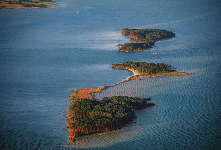
The photo gallery on this page bears witness to a changing landscape. For decades, Bay Journal photographer Dave Harp has been documenting the withering of James Island in the Chesapeake Bay.
When first settled by the English in the 1660s, the island is believed to have boasted about 1,350 acres of dry land off Maryland’s Eastern Shore, where the Little Choptank River spills into the Bay.
Today, not much remains of the archipelago except a few clumps of mud. Rotting stumps and a fallen trunk or two are all that remain of the thick stands of trees that once graced the terrain. A few lie visible beneath the water.
These images, compiled between 1999 and October this year, present a dramatic depiction of the shrinking island, a victim of erosion and a changing climate. Over the past 100 years, they have driven sea level up by about a foot in the Chesapeake region, and it’s on track to swell another 4 feet by the end of this century, climate scientists say.
I can't embed the slide show (alas), but the first picture is approximately the James Island I walked on in the 2000 (the picture is from 1999).
 |
| James Island 1999 |
 |
| James Island 2022 |

Thank goodness they were wrong:In 1995, experts told the NY Times that east coast beaches would be wiped out by 2020; forecasts based on models. Despite being wrong, rapid acceleration scenarios are still used today. Obviously didn't learn a darn thing. “Climate science is where arrogance and ignorance meet.” pic.twitter.com/w6yaNyht7a
— Chris Martz (@ChrisMartzWX) November 1, 2022

WBOC, Proposed Dredging Project for Tangier Island
A $25 million investment has been proposed to help slow the erosion on Tangier Island. The investment would be used for a dredging project that would place dredged material from the Virginia part of the Chesapeake Bay onto the island. The project is not a done deal, but islanders hope it is soon. One of the main reasons islanders want it done quickly is because it's starting to affect the crabbing sheds.
"Our seas come in shore farther, and that's starting to encroach on top of the crab buildings that we have out here that sheds our soft shell crabs," said Norwood Evans, Tangier Islands Vice Mayor. "So any restoration work we can have done to help protect their inside harbor and all is a benefit for the waterman and the island itself."
The erosion is so bad in Canton Ridge, that areas where land used to be, are completely submerged. Wildlife have also been affected, as they've seen much of their habitats disappear over the last 20 years. Loss of habitat is just one of the reasons Vice Mayor Evans wants this project to move forward.
"It'll help build embankments up and stop the surge coming, and then it will also help with the turtles that nest in the area," said Evans.
Before anything can happen, however, the plan needs congressional approval.
"We're not there yet," said U.S Senator Tim Kaine. "I got to get it through the senate and then I got to rely on Congresswoman Luria on the house side, and we'll make this happen."
As of right now, there is no timetable for when the project could pass both the house and senate. Kaine and his office are hopeful that it happens sooner rather than later, but they say it's still up in the air.
$25 million is rounding error in the federal budget, so it would seem a reasonable request to save a historic community, although it would only benefit about 400 people directly.
But is this a problem? US election: The sinking island voting for Trump
Tangier Island is slowly disappearing due to erosion and rising water levels, but this US community of fishermen is putting its faith in a sea wall - and President Trump - to protect their homes, jobs and way of life.
Tangier voted 88.6% for Trump, 9.3% for Biden. Maybe in the next Congress?
It's sinking away! Bay Journal, With waters rising, Baltimore eyes $138 million plan to limit coastal flood damage
With Baltimore facing increased risks of coastal flooding from storms as sea level rises, federal officials have put forward a $138 million plan aimed at protecting the interstate highway tunnels under the city’s harbor while reducing flood damage to homes and businesses in low-lying waterfront neighborhoods.
The draft plan released earlier this month by the Baltimore District of the U.S. Army Corps of Engineers proposes to build floodwalls around the openings to the Interstate 95 and Interstate 895 tunnels that carry traffic beneath the harbor. Flood barriers would also shield the ventilation buildings that circulate fresh air into the tubes.
For the tourism-centric Inner Harbor and waterfront neighborhoods like Canton, Fells Point, Riverside and Locust Point, the plan doesn’t envision erecting any levees or other structures to hold back the water. Instead, it calls for floodproofing vulnerable buildings to the greatest extent possible, given their age and condition.
“The goal is to mitigate damage,” explained Joseph Bieberich, project manager for the Baltimore District’s coastal storm risk management feasibility study.
The draft plan is the product of a three-year study for which the Maryland Department of Transportation picked up half of the $3 million cost. It’s an outgrowth of an earlier Corps study of East Coast flood risks, which projected that sea level in the harbor could rise from 1.0 to 5.4 feet by 2100, depending on the severity of climate change.
The Baltimore metropolitan area has felt the effects of at least nine hurricanes or tropical storms since the 1950s, the Corps study noted. The most severe hit came from Tropical Storm Isabel in 2003, when storm surge and heavy rains inundated the Inner Harbor and neighborhoods in Baltimore County with up to 8 feet of water. It caused $4.8 million in property damage in the city and up to $252 million in total damages in the county. One person died in the floods, while more than 570 homes and 15 businesses were declared uninhabitable.
Even without storms, portions of the area experience tidal flooding several times a year, particularly the Inner Harbor promenade and the mix of businesses and homes in lower Fells Point. With climate change pushing the sea level higher, the National Oceanic and Atmospheric Administration predicts the city could experience anywhere from 50 to 160 nuisance flooding events by 2050, inundating a broader swath of the waterfront.
Between storms and nuisance flooding, the Corps plan says, more than 1,400 structures would be at risk by 2080.
 |
| Sea Level in Baltimore - NOAA |
 |
| The CO2 Study |
Wetlands across the globe are in danger of drowning from rising seas. But for decades, scientists held out hope that another aspect of climate change—rising carbon dioxide (CO2)—could trigger extra plant growth, enabling coastal wetlands to grow fast enough to outpace sea-level rise. That helpful side effect is disappearing, they discovered in a new study published May 18.
“Too much water is a stress, an environmental stress, for plant response to high CO2,” said Chunwu Zhu, lead author of the report in Science Advances. Zhu, a biologist with the Chinese Academy of Sciences, conducted the study while on a fellowship with the Smithsonian Environmental Research Center (SERC).
. . .
The study took place at SERC’s Global Change Research Wetland, a research site Megonigal runs on the western shore of Maryland. The wetland is home to several futuristic experiments, where scientists simulate the climate of 2100. For this study, the researchers relied on an experiment that started in 1987—currently the world’s longest-running field experiment on how rising CO2 impacts plants. Inside 15 open-top chambers, scientists have been raising CO2 concentrations by an additional 340 parts per million, roughly doubling atmospheric CO2 levels of 1987. Another 15 chambers serve as controls, with no added CO2. The team focused on the 10 chambers with “C3” plants—a group of plants known to respond vigorously to high CO2 that includes roughly 85% of plant species on Earth.
For about the first two decades of the experiment, plant growth in the higher CO2 chambers flourished. Above ground, plants in the high-CO2 chambers grew on average 25% more than plants in the untreated chambers. The effect was even more powerful underground: High CO2 triggered about 35% more root growth. Root growth is especially critical for wetland survival, as roots help wetlands build soil and keep the foundations growing upward even as seas continue to rise.
 |
| The Methane Study |
“Even though elevated CO2 contributes to sea-level rise, it also enhanced the marsh’s ability to accrete vertically during the early years of the experiment,” said Don Cahoon, a coauthor and research ecologist, emeritus, with the U.S. Geological Survey.
But after 2005, the effect declined and vanished. For the last 14 years of data in the study, there was no average difference in plant growth between the high-CO2 and normal chambers.
“The CO2 effect has always been one of the silver linings of climate change,” said coauthor Adam Langley, an ecologist with Villanova University. “Well, at least plants are going to grow more. But we see here that they didn’t. So the silver lining to me just got a little cloudier.”
The team examined several possible explanations for the drop-off: precipitation, temperature, the saltiness of the water during growing season or the presence of critical soil nutrients, like nitrogen. Only sea-level rise showed any link to plant growth. Once sea levels at the wetland rose 15 centimeters above where they began in 1987, the benefits of higher CO2 disappeared.
These are friends and former co-workers of mine, but I urge caution regarding over-interpretation of the result. As natural as they try to make it, these are altered habitats due to the enclosures to hold the CO2 in. To expect them to behave like the real world 20 years after they were installed seems, shall we say, optimistic?
Here's a link to the Facebook page for this project: GCrew
Let's see, I was born in 1951. I'll be 99 when this bet comes due. WaPoo, Sea level to rise one foot along U.S. coastlines by 2050, government report finds
The shorelines of the United States are projected to face an additional foot of rising seas over the next three decades, intensifying the threat of flooding and erosion to coastal communities across the country, according to a report released Tuesday by the National Oceanic and Atmospheric Administration.
Human-caused climate change, driven mostly by the burning of fossil fuels, has accelerated global sea level rise to the fastest rate in more than 3,000 years. The report by NOAA, NASA and five other federal agencies — updating a study from 2017 — predicts that ocean levels along U.S. coasts will increase as much by 2050 as they did over the past century.
Sea levels are rising around the world. Here's how high they could reach.
This amount of water battering the coasts “will create a profound increase in the frequency of coastal flooding, even in the absence of storms or heavy rainfall,” NOAA said.
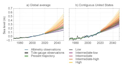 |
Projections of sea level rise — relative to a baseline of 2000 — for five emissions scenarios and an extrapolation of observations (labeled as present trajectory) for the globe and contiguous United States. (NASA-JPL/Caltech) |
“We’re unfortunately headed for a flood regime shift,” said William Sweet, an oceanographer at the NOAA National Ocean Service and the nation’s top scientist on sea level rise. “There will be water in the streets unless action is taken in more and more communities.”
Drawing on data from tidal gauges and satellite imagery as well as cutting-edge models from the most recent United Nations report on climate change, the NOAA analysis gives decade-by-decade projections for sea-level rise for all U.S. states and territories over the next 100 years. Advances in ice sheet modeling and better observational data allowed the authors to give more definitive near-term projections than ever before, Sweet said.
Except, there's just no evidence that the rate of sea level rise is really increasing in the only real data, the tide gauges scattered all over the world. For example, Baltimore.

At WUWT, Rud Istvan has a post, Sea Level Alarm, on how the word appears to have gone out to promote this scare mongering. I think they must be getting pretty desperate to get people to pay attention to them to go out on a limb like this. What happens when 2050 comes, and sea level has only risen by the 4 inches that current rates of sea level rise suggest? Give us our money back, quit their jobs, and wear sack cloth and ashes? Nope, they'll just move the goal posts, and promise that the world is going to end in the next 50 years, if we don't fund their work, and follow their pronouncements.
 |
| East River Park |
After years of planning by city officials, New Yorkers got a close-up glimpse of the trade-offs inherent in the fight against climate change when crews this month began cutting down the first of a thousand trees targeted for removal in John V. Lindsay East River Park.
Since the chain saws arrived two weeks ago, workers have moved quickly to get rid of more than 70 species of mature trees at the popular 46-acre park on the Lower East Side, including 419 oaks, 284 London planes, 89 honeylocusts and 81 cherry trees — along with eventually demolishing a running track, ballfields, lawns, picnic areas, an amphitheater and a composting center.

“What’s the point of paying a parks department that cuts down trees?” asked Karen Kapnick, one of a small group of protesters who watched in horror, peeking through a chain link fence next to Franklin Delano Roosevelt Drive as workers denuded the first dozen trees. “I’m just here because I care about the trees and the environment.”
City officials say the tree removal is just a necessary first step to creating a bigger and better park. More importantly, they say, the remade East River Park will be better able to withstand storm surge even as the waters surrounding lower Manhattan rise in the coming years. Once all the work is finished — projected in about five years — the new park will be raised 8 to 10 feet higher, with new recreational facilities and 1,800 replacement trees representing more than 50 species more suited to survive occasional saltwater floods.
The park overhaul, spurred by the destruction of Superstorm Sandy in lower Manhattan nearly a decade ago, is all part of a $1.45 billion flood protection project that backers say befits the nation’s largest city, a massive project that will include the construction of a 2.4-mile system of walls and gates along the East River.
“We’re the parks department, so we obviously are very fond of trees and plants,” said Sarah Neilson, chief of policy and long-range planning for the New York City Department of Parks and Recreation. “We also recognize that after Sandy we had to take out 250 trees that died just from that one intense saltwater inundation. They’re not species that were designed for a coastal environment.”


