Island, that is. At the Bay Journal, A photographic farewell to James Island
The photo gallery on this page bears witness to a changing landscape. For decades, Bay Journal photographer Dave Harp has been documenting the withering of James Island in the Chesapeake Bay.
When first settled by the English in the 1660s, the island is believed to have boasted about 1,350 acres of dry land off Maryland’s Eastern Shore, where the Little Choptank River spills into the Bay.
Today, not much remains of the archipelago except a few clumps of mud. Rotting stumps and a fallen trunk or two are all that remain of the thick stands of trees that once graced the terrain. A few lie visible beneath the water.
These images, compiled between 1999 and October this year, present a dramatic depiction of the shrinking island, a victim of erosion and a changing climate. Over the past 100 years, they have driven sea level up by about a foot in the Chesapeake region, and it’s on track to swell another 4 feet by the end of this century, climate scientists say.
I can't embed the slide show (alas), but the first picture is approximately the James Island I walked on in the 2000 (the picture is from 1999).
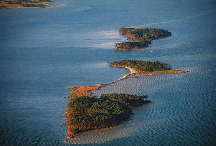 |
| James Island 1999 |
I recall walking across that narrow strip connecting the two lower islands. It was about a foot wide and composed of salt marsh sod. Very little remains today. We can no longer see it from the beach.
 |
| James Island 2022 |
Of course, disappearing islands is nothing new to Chesapeake Bay. James Mitchner fictionalized Sharps Island as Devon Island in his novel Chesapeake, with Devon Island disappearing at the end of the book, long before the era of "global warming." Today, Sharp's Island is only found as a shallow bank with a light house located on it.
Just a reminder that sea level in the Chesapeake Bay has been rising a constant rate since we began to keep track of it:

you are telling stories that just do not make any sense. why is plymouth rock the same after 400 years? sea levels are not rising and global warming is a lie. i bet you believe carbon is bad.
ReplyDeleteExactly who was around?, using what? to measure the sea level at baltimore in 1900?
ReplyDeleteTo Jmparret, yes, sea level is definitely rising, and has been more or less consistently since the termination of the last glaciation about 14,000 years ago. Currently the average rate is about 2mm/yr, but varies dramatically depending on whether the land is subsiding or rising. We in the mid Atlantic are subsiding due to glacial rebound, water withdrawal from aquifers, and the continues subsidence into the Chesapeake Meteor crater near the mouth of the Bay from ~35 million years ago. Plymouth rock is not proof to the contrary, it was moved to it's current location in 1920, and was not even considered a landmark for the Pilgrims landing until long after the actual event. And it does occasionally go under water at extreme high tides now. No, carbon isn't bad (but you can't breath pure CO2 either). I'm a Bjorn Lomberg/Judith Curry type believer in "global warming". It's being exaggerated for political purposes, it's likely not harmful, more likely beneficial, and we really don't know how much humans influence it compared to natural climate fluctuations.
ReplyDeleteAnon, I haven't been able to trace who established the tide gauge network, but the earliest govt tide data post-date the establishment of USGS in 1879, although that function was moved to NOAA subsequently. Tide gauges aren't really hard to make, a simple stilling pipe (a pipe with small holes so water comes in too slowly to be affected by waves) attached to a well-sunk piling or convenient rock, a floating stick, and a simple recording device, probably mechanical traced on paper in the good old days, now electronics. I would guess private tide gauges were kept by shipping companies, harbors etc. before the govt. stepped in. Govt tide gauges appeared at major ports first, and then spread to smaller sites.
ReplyDeleteyou can still see the rock exactly as described.
i hope you have plans to live without gasoline and diesel. food will also be a problem.
if it rises in one place it will rise all over. islands disappear because of erosion.