NOAA Office of Coast Survey navigation response teams and other survey assets are in the water, as they begin checking for underwater debris and shoaling that may pose a risk to navigation. Tasked by the U.S. Coast Guard Captains of the Port, these vessels can use multibeam echo sounders or side scan sonar, as conditions warrant, to search for the answers that would speed resumption of shipping and other vessel movements:It's not uncommon for major storms to cause massive movements of sediments, eroding them in some places, and building them up in others. The area just south of us at Flag Ponds Park is reported to have been created by a major hurricane in the '30s which built up the sand bars, and closed off the ponds behind them.
- NOAA Ship Ferdinand Hassler spent time surveying deep draft ship channels in Chesapeake Channel and Thimble Shoal Channel, as 78 large vessels, including portions of the Navy's Atlantic Fleet, waited to transit through the entrance to Chesapeake Bay.
- NOAA R/V Bay Hydro II is surveying in the Hampton Roads area, checking channels needed by coal shipments and aircraft carriers at Norfolk.
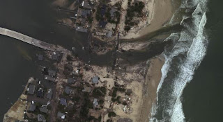
An interesting example from coastal New Jersey, the town of Mantoloking, from Hurricane Sandy:
 |
| Pre Hurricane Sandy |
 |
| Post Hurricane Sandy |
However, given Sandy's relatively light effect here, I'm not expecting to run into a new sand bar the next time I go fishing.
No comments:
Post a Comment