Showing posts with label Hurricane Irene. Show all posts

Friday, August 5, 2016

Oh No!

Claim: global warming driven extreme weather will increasingly disrupt striped bass fishing holes
Researchers from the University of Maryland Center for Environmental Science wanted to know the impact of severe storms on fish populations that have to make sudden and unexpected trips downstream, away from their preferred habitat, to more hospitable waters. Thanks to global warming, waterways that make up important habitat for fish are likely to experience an increased frequency of such extreme conditions.

“These events happen naturally, but having them occur more frequently may have a bigger impact on the fish,” said the study’s lead author Helen Bailey. “If you get more frequent storms during the year, it is possible you could interrupt their breeding and feeding in ways that impact their population.”
Curiously, in the era of global warming, however, there has been a dearth of actual severe storms and hurricanes hitting the east coast of the United States. You would not know this from news coverage, however, who continue to present each negative weather event as a "fore sure" global warming caused catastrophe:


Bailey and Dave Secor tracked 22 striped bass in the Hudson River Estuary (which hosts one of the largest populations of this species) and New York Harbor during the Tropical Storms Irene and Lee in 2011. Occurring about a week apart, the significant weather events caused heavy rainfall, major flooding, and sudden influxes of fresh, cold water into the waterways.
Curious; a Maryland scientist studying stripers in the Hudson and not the Cheaspeake; I'm going to hazard a guess that the availability of funding is involved.
The year before, during normal conditions, researchers had tagged the fish that lived there with small electronic transmitters that regularly pinged their every move. After the storms, they were able to compare the data to examine how their behavior was impacted by the extreme storm events.

“There are very few studies on this because it so hard to sample during these storm events. You can’t predict when they will happen and these can be hazardous conditions to work in,” said Bailey. “Telemetry data gave us the opportunity to do it.”

The researchers discovered that when the storms hit, most of the fish rapidly left the Hudson River and New York Harbor, moving south along the coast. A few remained in the harbor and were able to avoid being displaced. Others did a few exploratory trips later back to the harbor to check on conditions over the next few months and eventually returned up the river.
Striped bass moved to avoid shitty conditions, and some of those who would ordinarily go to soon after, stayed away?
“It’s not unusual for fish to be leaving this area at this time of year,” said Bailey. “What was very unusual was that so many of them did it, they went so far south, and they did it so quickly.”

There were several changes to the behavior that the researchers didn’t expect. Most concerning, depending on when the storm events occurred, some of the striped bass that evacuated the areas did not immediately return, adopting new migration behaviors.
So, we can conclude that global warming, which appears to actually decrease the number and severity of strong storms, is good for stripers?

Wombat-socho has "Rule 5 Sunday: Gold Medal, Ahoy!" ready for inspection at The Other McCain.

Tuesday, April 23, 2013

2012 A Bad Year for Bay Weeds

Chesapeake Bay Sees 20% Drop In Underwater Grasses 
Underwater grasses in the Chesapeake Bay declined more than 20 percent last year, according to scientists. It was a blow to many fish as well as other species that need the grass to live or breed. Underwater grasses create meadows of sorts beneath the surface; those areas are where all kinds of creatures like crabs and striped bass live and breed. Last year, some 17,000 acres were wiped out.

Scientists with the federal Environmental Protection Agency's Chesapeake Bay Program survey bay grass levels annually; they say bay grass coverage has now dropped to its lowest point since 2006 and is at historically low levels. The researchers blame extreme weather: heavy rains and snow melt sent tons of mud and debris into the bay last year, and record setting summer heat killed off many acres as well.
I really don't recall last year being that awful by comparison with other recent years, but maybe that just means I've spent too much time blogging and not enough time fishing.  Well, there was that pesky "Superstorm Sandy", but I thought it was kind of a dud for impact on the Bay, at least compared to Hurricane Irene and Tropical Storm Lee in 2011.

Here's a graphic from the EPA Bay Program to put it into perspective:


Not a lot of progress toward the goal of 180,00 acres of SAV the Bay Program has set as the goal for two years ago.

Monday, April 23, 2012

Mild Atlantic Hurricane Season Forecast

We anticipate that the 2012 Atlantic basin hurricane season will have reduced activity compared with the 1981-2010 climatology. The tropical Atlantic has anomalously cooled over the past several months, and it appears that the chances of an El NiƱo event this summer and fall are relatively high. We anticipate a below-average probability for major hurricanes making landfall along the United States coastline and in the Caribbean. However, coastal residents are reminded that it only takes one hurricane making landfall to make it an active season for them, and they need to prepare the same for every season, regardless of how much activity is predicted.
But remember, it only takes one; stay prepared...

Full forecast here.

Friday, April 13, 2012

We Went for a Walk

We stayed home today for the memorial service for a friend today, but before I left I took Skye on a walk around the neighborhood.

Georgia's attempt to out do Van Gogh's Irises.
 A native azalea blooming in the woods behind our house.  Looking here, it's not entirely clear which species it is but Rhododendron periclymenoides seems like a good fit (except the range map shows none in Calvert County),
 An Eastern Dogwood in full bloom.
 Lots of Mayapple, fully spread, but no apples yet.
Native American Bamboo, called River Cane or Canebreak.  You find dense patches of it here and there.  Supposedly they supplied Indians Native American with arrow shafts.
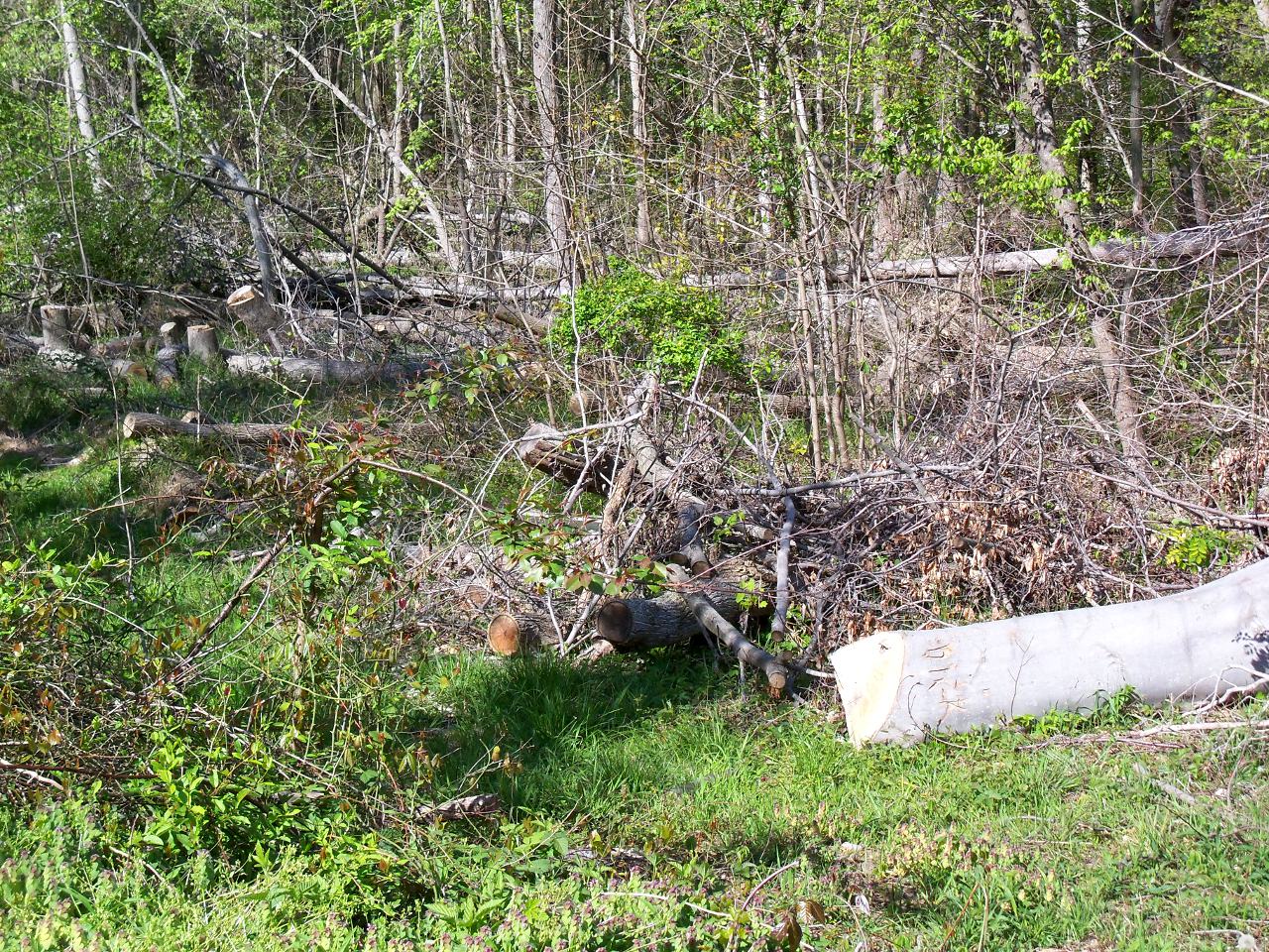
 A tangle of trees knocked down by Hurricane Irene (really only a tropical storm here).  In this patch, most of the big trees went down.  It's a marshy area, so maybe the ground was softer than other places, or maybe it had a microburst or tornado embedded in the storm.  If a tropical storm did this, I don't want a hurricane.
A crow giving us the evil eye as we walked past.

Tuesday, February 14, 2012

Good News from the Oysters

Maryland’s Department of Natural Resources says oysters are surviving at the highest rate since 1985.

The department says results of its fall oyster survey show 92 percent of oysters were found alive in samples taken baywide. The two-month survey sampled 263 oyster bars throughout the bay.

While heavy rains last year caused high mortality in some areas, the department says lower salt levels throughout the bay helped cut diseases that have devastated oyster populations. DNR says the high survival rate also comes on the heels of a strong spatset, or crop of baby oysters, which was the largest last year since 1997.

Maryland is emphasizing oyster aquaculture and sanctuaries to restore its oyster population, which is at less than 1 percent of historic levels.
This is indeed good news, but I have this word of caution.  Since it immediately followed a devastating oyster die off  in the upper caused by the intense flooding from Hurricane Irene and Tropical Storm Lee, the high survival of the remaining oysters may be an artifact.  By eliminating many oysters in less favorable, low salt habitats, the floods may have "pre-killed" a large number of the oysters in advance of the study, leaving an artificially high survival rate for those remaining.   It's easy to take good news on its face, but you need to look at some of the underlying causes as well

Tuesday, October 4, 2011

What Irene Giveth, Lee Taketh Away

One of the few "blessings" of Tropical Storm Irene was that the strong winds mixed the Bay, and ended the annual occurrence of anoxic water in the Bay early.  Now we find that the massive amounts of nutrients, sediment and freshwater entering the Bay as a result of the remnants of Tropical Storm Lee have fueled another outbreak of anoxia:
The director of the University of Maryland's Horn Point laboratory says heavy rains from Tropical Storm Lee are causing low-oxygen areas in the Chesapeake Bay.

Laboratory director Mike Roman returned to the Cambridge lab Wednesday after eight days aboard the University of Delaware's research vessel Hugh Sharp. Roman told The Star Democrat of Easton (http://bit.ly/nagyir) that researchers found low-oxygen levels and dead water from north of the Bay Bridge to south of the Patuxent River.

While the storm and flooding stirred bay waters, flushing out a dead zone that had grown over the summer, it also brought debris, pollutants and nutrients that can fuel oxygen-robbing algae blooms.
The one thing I've learned you can count on is that every years is different from the last one...

Monday, September 19, 2011

Ready or Not, It Came

A few days ago, I predicted a huge stranding of wood and trash at the beach, washed down by Irene and Lee.  We arrived at the beach this morning to discover that it had washed in sometime while we were up in Pennsylvania, occupied with other things.
Mostly, it's just woody debris that has fallen into streams and lakes along the drainage, but a fair amount of human trash is mixed in too.  Lots of ruined buckets, motor oil jars, etc.
A little fishing tackle is in the mix, too.  I picked up a couple of bobbers, and this Jitterbug, which will be usable after I bend the lip back into shape, and hang a couple of new treble hooks off it.
There are several large logs bobbing around in the surf.  These are serious boating hazards, especially when you are running at night, and can't see them clearly.
Georgia picked up a few tennis balls.  This is what she collected over about a quarter mile of beach.  Now imagine extrapolating that to all the many miles of shore between here and the Susquehanna River, and even the shoreline farther south.  Where do all those lost tennis balls come from?
It was so difficult to walk through the trash around the corner above, that we came back on the road.  I got this picture of a small butterfly in the weeds.  I don't have a clue what type it is...

Tuesday, September 13, 2011

Ready or Not, Here it Comes!

In this satellite photo of Chesapeake and Delaware Bays you can see the huge slug of dirty water coming down from the rivers and into the Bays:


I got the picture here, but I played with the brightness and contrast some to make the difference between land, water and mud more obvious.  You can find up to date originals here.

Monday, September 12, 2011

The Aftermath of Tropical Storms Irene and Lee

Irene was a disaster for lots of us living on shore, but her impact on the Bay was not that severe, in fact, in one respect, it had positive effects, it's strong winds turned over and mixed the bay water, cleaning up the "dead zones" which had settled in the bottom waters:
Hurricane Irene's high winds breathed a little life into the polluted Chesapeake Bay, bringing short-term relief to wildlife by temporarily eliminating the estuary's vast dead zone, according to the Maryland Department of Natural Resources.

The bay's dead zone - a stretch of deep water stretching from Baltimore to Virginia, with dissolved oxygen levels too low to support most aquatic life - emerges every summer and naturally fades with the fall. But this year's dead zone diminished earlier than usual after Irene whipped through the area, mixing layers of water containing varying levels of oxygen.

The revived waters could provide a habitat for marine life in places that were previously not livable, said Jenn Aiosa, Maryland senior scientist for the Chesapeake Bay Foundation.

"It might open up additional habitat that, three weeks ago, wasn't hospitable because the oxygen was low," Aiosa said. "A greater volume of the bay with oxygen is good, primarily for the fish that transit the bay - and, you know, if there's more fish available, birds or the wildlife that rely on those fish species would also benefit."
Tropical Storm Lee, on the other hands, which manifested largely as a long rain event over a large area of the Northeast, with widespread flooding is causing substantial problems:
Near record flows on the Susquehanna River are bringing sewage, sediments and other pollution into the Chesapeake Bay. And that’s threatening bay grasses, oysters and other key species that help improve the bay’s water quality.

The Chesapeake Bay Program says that in addition to the Susquehanna, high flows are also being measured on other waterways in the six-state bay watershed, threatening to cover bay grasses and oyster beds in sediment. Floodwaters could also dilute the salt in the water that oysters need and free chemicals in sediment trapped behind the Conowingo Dam along the Susquehanna.

On the positive side, the bay program says flooding happened after the main bay grass growing season, and sewage and other pollutants are less likely to cause algae blooms now than earlier in the year.
Many observers report extremely turbid waters and large amounts of floating debris, natural and otherwise, further up the Bay.  As we have seen previously, I expect to see major amounts of debris land on our beach in a few days, depending on winds and tides.

People are already starting to talk about the aftermath of Lee as the worst event since Hurricane Agnes in 1972, which had similar flood waters, and caused substantial and long lasting harm to the Bay by lowering the salinity over large areas, and killing animal and plants intolerant of fresh water, and by smothering many more with silt.

Scientists are already at work out on the Bay, trying to see how bad the effects have been.

Tuesday, September 6, 2011

Hurricane Irene Caused Baltimore Sewage Spill

Hurricane Irene leaves sewage spills in wake
Hurricane Irene did more than topple trees and turn out the lights across the Baltimore area. The storm left behind some nasty, stinky reminders of its fury, as sewage spills forced beach closures and triggered warnings to stay away from the water as summer draws to a close.

The worst problem came in the Baltimore Highlands area southwest of the city, where a ruptured sewer main has poured about 100 million gallons of raw sewage into the lower Patapsco River over the past week. Power outages also led to more than a dozen other sewage spills across the region...
It's an old story.  The sewage infrastructure on the old big cities is in pitiful shape, and the cities will not spend the money to upgrade them, preferring to wait until forced and preferably bribed with federal money, to fix it.  Cities are the locations of wealth in our society, but they can't be bothered to solve their own waste problems as long as they are allowed to export it.

Monday, September 5, 2011

Ode to Irene

We lost it when Irene blew through
Wi-Fi, laptop, iPad, too
On my Kindle, no bars found
Oh lord, the Internet is down

My Facebook friends no longer poke
I cannot tweet a single joke
My iTunes offer not a sound
Now the Internet is down

I finally fix that yellow chair
Clean my office, wash my hair
Then I wander all around
Now the Internet is down

The library's packed. And Starbucks, too
I need my fix. Can I sit here too?
Is Wi-Fi in another town?
Now the Internet is down

You know, this thing could change my life
That woman there? Seems she's my wife
I wondered why she hung around
Now the Internet is down

I have a daughter! Son! It's true!
A family. Job. Good grief, who knew?
I feel better. My mind is sound
Now the Internet is down

I'll search the house and find a nook
To finally read that Hawking book
My thoughts are clear, my soul unbound
Now the Internet is down

I'll study Zen. Take up guitar
I'll search for wisdom near and far
To Internet's death, I raise my cup
Wait. Never mind. It came back up


Hat tip to Janie.

Wednesday, August 31, 2011

Irene a Mixed Bag for the Bay

Storm a boon, bane to the Bay
"There are good things that can come out of this," said Chris Moore, a water quality scientist with the Chesapeake Bay Foundation. "The one species that this could really help is the blue crab."

Blue crabs spawn near the shore, but their larvae float out into the ocean, often more than 50 miles out, Moore said. High winds from hurricanes could carry many of the juvenile crabs toward the shore and away from larger predators, like sharks and sting rays.

High winds may also benefit fish and shellfish populations in the Bay and in nearby rivers that have dead zones, areas that lack the amount of oxygen in the water necessary for aquatic life to survive.
On the downside, the high rains (we got seven inches, other areas reported up to eleven), wash in sediment and pollutants:
"The streams that feed major rivers are likely to have larger loads and more erosion than normal," Moore said. "The biggest concern is that we might see a much larger slug of nutrients, pollutants and sediment entering the Bay."

Development in the Bay watershed has reduced wetlands and increased hard surfaces, such as paved streets. The result is that more rain water enters streams as runoff, carrying pollutants with it, rather than being absorbed into soft ground.

Sewage overflow is also a concern, particularly for the Bay.
I've heard the fishing is better now, too.  Too bad my boat is still high and dry, awaiting a new coat of bottom paint.

Tuesday, August 30, 2011

For Guys Who Fix the Power


A job that probably hasn't got much easier since the 70s.

Still Cleaning Up!

Spent the last couple of hours splitting wood downed by Irene. I only got one blister.

We got our cable back sometime today while we were at work.

Hang On, Hang On!

Internet still out due to Irene!

Monday, August 29, 2011

Landscaping by Irene

First the good news.  We came through Irene basically unscathed.  Our internet went out for good shortly after my last blog update, the power went out at 8:15 PM (according to the one analog clock still in the house).  We went to bed early in the dark, and slept surprisingly well, even as we heard big gusts, and breaking timber.  When we woke up it was still raining and gusty.  It was apparent that the neighborhood had been hit pretty hard:

This large Poplar tree went down between our house and the next door neighbor (it was on our lot).  It survived the ice storm of 1995, even though most of it's upper limbs were broken off.  Behind it and to the left, you can see a leaning tree trunk.  That's a medium sized Hickory tree, again on our lot and leaning to the neighbors.  It's pretty well hung up in another tree, so I think we have a while to deal with it.
Others were not so lucky.  This house on our street was badly damage by a tree that fell into it.  Out of 20 houses on our street, at least 4 were struck by falling trees.

Before breakfast, I went out to check on a friends house (he's away).  The house was OK, but he lives nearer the bay, and I stopped to take this photo from near his steps.  By now the effects of Irene were clearly waning.

A shot of our front yard, showing the shredded twigs and leaves that covered everything.  Once the rain stopped, I got the chain saw out and began to cut up the big limbs, and the downed Poplar.  The sun came out and it was a pretty nice day after that (still a bit breezy).  After I made moveable chunks out of the limbs, we cleared the yards, and I mowed and bagged all the trash for our compost heaps. 

Our power came back on about 6 PM, as we were eating shrimp boiled on the propane grill.  We did a little more cleaning after that, and went to bed tired at 9 PM.  Still no phone, cable or internet.

OK, that's long enough in the 19th Century.

Saturday, August 27, 2011

Well, It's Begun

Irene that is. As of  9:00 AM, by radar and media reports the center of the storm has come ashore in North Carolina.  Outer bands reached us about 8 AM, and it started to rain.  Not too much yet, maybe a couple of millimeters (or in 'Merican units, just a hair) .  Breeze has picked up and the tops of the trees are swaying, but nothing extreme.

More reports later as it gets more exciting.


10 AM UPDATE.  Heavy rain, wind is rising (as you can see above).  I went and took the fishing tackle out of the boat box in case the storm surge floods it.  Georgia ran into town for a few last errands.

It looks like the storm surge has just started to affect us here:


A few shots from the beach, taken at ca 10:30 AM

Looking south toward the old part of Long Beach.  Winds are about 20 mph at this point, and waves are picking up.
A zoom on the waves hitting the rip rap walls.  This makes it look much worse than it really is; the biggest of those wave are probably on two or so feet at this point.  It will take another few hours of a good stiff wind to build up to waves much above 5 feet here.  The short fetch and the shallowness of most of the bay make it hard to build really big waves here.  But what they lack in height they make up for with choppiness...
Looking north, a familiar view.  I wish I had a good water proof camera for this.


11 AM UPDATE:  It's still raining hard, we've had about a half inch since 8 AM.  Wind is still climbing; it's up to about 25 mph sustained winds at Cove Point (a few miles south). Our power is still on (and that's a good thing); this much wind is apt to knock something down into the lines somewhere in our distribution links.

11:30 AM UPDATE: Calvert County just issued evacuation orders for all dwellings within 100 ft of the cliffs.  That seems a little extreme to me...

12:00 NOON UPDATE:  We're getting serious rain here now, and the winds are up to 30+ mph sustained and still climbing.

1:00 PM UPDATE: Not much change; we have 1 inch of rain in our rain gauge, and it's falling hard. Winds are holding around 30 mph. The power has blinked a couple times...

2:00 PM UPDATE: No Significant changes, still windy and rainy; the power continues to blink, my UPS seems to be doing it's job.

3:00 PM UPDATE:  Much the same, we had one short power outage.  Wind was up a bit in the last hour, nearing 35 mph sustained.  Not enough to kick us into "Tropical Storm" category yet.

4:00 PM UPDATE.  Still about the same.  We've had 2 inches of rain by now.  One big branch came down in the driveway, and green leaves are scattered all over the ground.

5:00ish UPDATE:  Multiple power blips, but nothing long lasting.  Wind has been near 40 mph a couple times.  Total rain up near 3 inches.  I see that Walleye Pete has posted this video of people down at the beach:


6:00ish UPDATE: Multiple short power failures, with occasional losses of internet connectivity. Winds are now sustained over 40 mph, official tropical storm force. Four inches of rain in the gauge.

Friday, August 26, 2011

OK, We're Ready Now


I found this four leaf clover at work today, so now we'll have good luck over the Hurricane Irene weekend!  And just because luck favors the prepared, we took in most of the loose missiles from around the house (and we have a few more to do tomorrow).  The boat has been pulled from it's slip, the bimini is safely off and in the garage, and we have enough food and water for quite a while.  We have flashlights, and batteries, and our chargeable electronics are being charged. 

I may be off the grid for a few days, or at least have limited access, so wish us the best!

Thursday, August 25, 2011

Hurricane Irene Update

Extra-tropical Storm Surge Predicted for Solomon's Maryland
Sucks to be us.  Hurricane Irene is shaping up to be a real bear.  The predicted track hasn't changed much since my last update, a near miss or a clip at the Outer Banks, then proceeding just offshore north striking the Outer Banks and skirting the shore until it slams into New York/Long Island.  The severe part of the storm will pass by late Saturday night to early Sunday morning; that leaves Saturday to take care of most of the needed preparations.

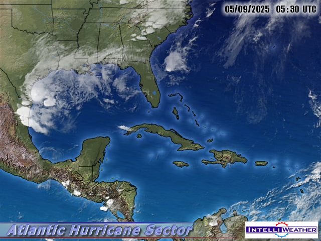
While it will be a good ways offshore here, the storm is  wide enough that we are expected to experience near hurricane force winds, 3-6 inches of rain, localized flooding, downed trees and limbs and storm surges of at least 1 feet above normal.  This picture should update itself as the storm approaches and passes, courtesy of NOAA.  Elsewhere on the coast, extreme storm surges are being predicted.

With luck, the marina will get my boat out of the water before it all starts, which will relieve me of that worry.  If wind predictions are severe enough, we'll board up the front windows. 

All in all, I expect a tough day, but hopefully, with good preparations and a little luck, no particularly onerous consequences.  Others who take a more direct hit from this extremely powerful storm are unlikely to fare as well.

Hurricane Irene Threatens US Coastline

Irene forecast to become a major hurricane, likely Category 4.

Click here to see in motion.


It has not escaped my attention that we are potentially in the area likely to be affected by high winds and excess rain...

I'll keep updating this one as new information comes in.

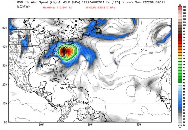
The newest set of predictions does not seem to be good news for us. Particularly if the modelers are leaning to the left side of the prediction envelope:


8/25 AM Update: The models seem to agree on a pass by or clipping of the Outer Banks, and coming ashore near New York. It's gonna be a bumpy weekend.