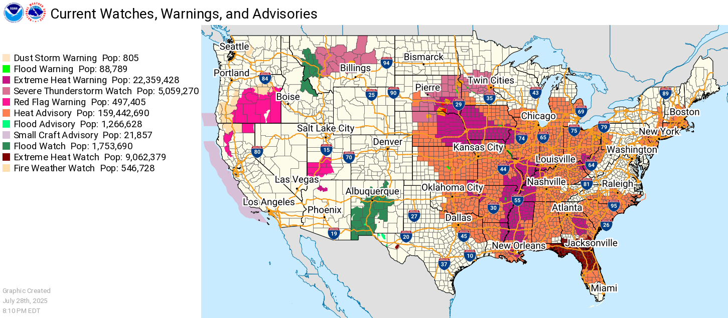
At least two people have died due to flash flooding in New Jersey after parts of the northeastern U.S. and mid-Atlantic were inundated with heavy rain Monday night. The storm caused flash flooding in areas of New York, central Virginia and New Jersey that gushed through subway stations, stranded vehicles and prompted a state of emergency.
Flood watches and warnings are still in effect through Tuesday evening for most of Virginia, Maryland and Washington, D.C., according to the National Weather Service.
Through Thursday, portions of the eastern and central U.S. are facing “scattered to widespread thunderstorms capable of heavy downpours and flash flooding,” the weather service said in its n most recent update on Tuesday.
One day you wash up on the beach, wet and naked. Another day you wash back out. In between, the scenery changes constantly.
Wednesday, July 16, 2025
The Wednesday Wetness
Saturday, July 5, 2025
It's Flooding Down in Texas
NewsMax, At Least 27 Dead in Texas Floods, Search for Missing Continues
A Texas sheriff says the deaths from flash flooding in central Texas has risen to 27 people, including nine children. Search and rescue efforts were continuing in the Texas Hill Country, said Kerr County Sheriff Larry Leitha. The destructive fast-moving waters along the Guadalupe River destroyed a girls' camp and washed away homes early Friday near the river. Many people remain missing.
THIS IS A BREAKING NEWS UPDATE. AP's earlier story follows below.
Crews searched through the dark early Saturday for two dozen children from a girls camp and many others still missing after a wall of water rushed down a river in the Texas Hill Country during a powerful storm that killed at least 24 people. The death toll was certain to rise.
The destructive fast-moving waters along the Guadalupe River rose 26 feet in just 45 minutes before dawn Friday, washing away homes and vehicles. The danger was not over as more heavy rains were expected Saturday and flash flood warnings and flood watches remained in effect for parts of central Texas.
Searchers used helicopters and drones to look for victims and rescue people stranded. The total number of missing was not known but one sheriff said about 24 of them were girls who had been attending Camp Mystic, a Christian summer camp along the river. Frantic parents and families posted photos of missing loved ones and pleas for information. "The camp was completely destroyed," said Elinor Lester, 13, one of hundreds of campers at Camp Mystic. "A helicopter landed and started taking people away. It was really scary." A raging storm woke up her cabin just after midnight Friday. And when rescuers arrived, they tied a rope for the girls to hold as they walked across a bridge with floodwaters whipping around their legs, she said.
At a news conference late Friday, Kerr County Sheriff Larry Leitha said 24 people were confirmed dead. Authorities said about 240 people had been rescued.
The flooding in the middle of the night on the Fourth of July holiday caught many residents, campers, and officials by surprise. Officials defended their preparations for severe weather and their response but said they had not expected such an intense downpour that was, in effect, the equivalent of months' worth of rain for the area.
One National Weather Service forecast this week had called for only between 3 and 6 inches of rain, said Nim Kidd, the chief of the Texas Division of Emergency Management. "It did not predict the amount of rain that we saw," he said. One river gauge near Camp Mystic recorded a 22 foot rise in about two hours, said Bob Fogarty, meteorologist with the National Weather Service's Austin/San Antonio office. The gauge failed after recording a level of 29 1/2 feet.
Timelapse flooding of the Llano River on July 4th pic.twitter.com/59Tnn6NZG7
— Rob Dew (@DewsNewz) July 5, 2025
Friday, May 16, 2025
Maryland, My Maryland
The Peacock, Boy missing, elementary schools in Maryland evacuated amid flooding
A 12-year-old was reported to have been swept away in Virginia, and rescuers in Maryland used boats to help evacuate elementary school students as heavy rain caused rivers to flood in several states Tuesday.
In Albemarle County, Virginia, the fire department said it searched for a 12-year-old boy who was reported to have been seen swept away by floodwaters. The search was paused overnight over safety concerns but was due to resume Wednesday.
A person called 911 at around 5:30 p.m. Tuesday and reported that the boy was swept away by rushing water that spilled from a creek onto a roadway, Albemarle County Fire Rescue said.
In Allegany County, Maryland, Georges Creek Elementary School and Westernport Elementary were evacuated, and students at a middle school were told to shelter in place, the Allegany County Department of Emergency Services said. No injuries were reported.
The flash floods in Maryland and Virginia occurred as more than 17 million people were under flood watches or warnings from southern Pennsylvania and West Virginia to North Carolina, according to the National Weather Service.
We got over an inch of rain on Tuesday into Wednesday, but nothing threatening.
Tuesday, November 26, 2024
I've Looked at Clouds from Both Sides Now
Penn State, Microplastics impact cloud formation, likely affecting weather and climate, just not very much.
Scientists have spotted microplastics, tiny pieces of plastic smaller than 5 millimeters, in some of the most pristine environments on Earth, from the depths of the Mariana Trench to the snow on Mt. Everest to the mountaintop clouds of China and Japan. Microplastics have been detected in human brains, the bellies of sea turtles and the roots of plants. Now, new research led by Penn State scientists reveals that microplastics in the atmosphere could be affecting weather and climate.
The study, published today (Nov. 7) in the journal Environmental Science and Technology: Air, demonstrated that microplastics act as ice nucleating particles, microscopic aerosols that facilitate the formation of ice crystals in clouds.
This means that microplastics could impact precipitation patterns, weather forecasting, climate modeling and even aviation safety by influencing how atmospheric ice crystals form clouds, explained Miriam Freedman, professor of chemistry at Penn State and senior author on the paper.
“Throughout the past two decades of research into microplastics, scientists have been finding that they're everywhere, so this is another piece of that puzzle,” Freedman said. “It’s now clear that we need to have a better understanding of how they're interacting with our climate system, because we’ve been able to show that the process of cloud formation can be triggered by microplastics.”
Oh my god, plastics cause clouds that block the sun, they rain and snow on everyone. So many things we could have done, but clouds got in the way!
They found that the average temperature at which the droplets froze was 5-10 degrees warmer than droplets without microplastics. Typically, an atmospheric water droplet without any defects freezes at about negative 38 degrees Celsius, explained Heidi Busse, a graduate student at Penn State and lead author on the paper. Any kind of defect in the water droplet, whether that’s dust, bacteria or microplastics, can give ice something to form — or nucleate — around. That tiny structure is just enough to trigger the water droplet to freeze at warmer temperatures.
So, basically, microplastics act just like any other form of dust, which is much more prevalent in the environment than microplastics.
Monday, October 28, 2024
The Monday Morning Stimulus
Friday, October 25, 2024
Rain Forest in the Rain
Wednesday, October 2, 2024
The Wednesday Wetness
D.C. could be in hot water if something ever disrupts the Potomac River’s drinking water supply. That’s according to a new report outlining the devastating economic impact a disruption would cause while urging for a better backup.
“If we do have an issue here in the District of Columbia, at the Washington Aqueduct, we have approximately less than 24 hours of water in supply,” David Gaddis, the CEO and general manager of D.C. Water, said during a news conference at The Wharf on Tuesday.
The report from the Interstate Commission on the Potomac River Basin revealed that a catastrophe on the Potomac — such as a severe drought, chemical spill, infrastructure failure or algae bloom — could disrupt the water supply for weeks. The commission found such a disruption could result in a loss of $15 billion in gross regional product within the first month.
I mean, what could go wrong? A hurricane?
The Wombat has Rule 5 Sunday: But First, Coffee up on time and under budget at The Other McCain.
Friday, July 19, 2024
Oregon, My Oregon
At WUWT, No, OPB, Climate Change is Not Taking a Toll on Oregon Farmers
The news site OPB [Oregon Public Broadcasting] posted an article titled “Climate change increasingly taking a toll on Oregon farmers, ranchers,” which claims that climate change is having such a serious impact on Oregon agriculture that farmers need special climate grief counseling to cope. This is false. OPB claims that droughts, wildfires, and heat waves are all getting worse with climate change, however data show that this is not true for Oregon.
OPB claims that farmers and ranchers in the state are “increasingly dealing with severe droughts, wildfires, sweltering heat waves and pests that can all-together decimate entire fields.”
Later in the article OPB says “more precipitation is falling as rain rather than snow in many areas of the Pacific Northwest,” and “there’s less snow and it melts earlier, which means less water will last long enough through winter and spring to feed streams and reservoirs for agricultural irrigators.” It is also claimed that summers are trending hotter, and extreme heat waves are more frequent.
Beginning with drought, Oregon has not been suffering from more severe droughts over time. According to data from the U.S. Drought Monitor, there is no indication that droughts in Oregon are worse today than they were 100+ years of warming ago.
National trends suggest that snowfall is decreasing slightly in late spring, but this doesn’t seem to be the case for Oregon as of yet, looking at data from the US Department of Agriculture National Water and Climate Center. (See figure below)
In fact, according to USDA data, which extends back to 1981, Oregon set its record for April snow-water equivalent in 2022, and second highest year was recorded in 2023.
Regarding wildfires, again, as Climate Realism has covered many times, U.S. wildfires are not getting worse, nor are they getting worse in Oregon.
According to the Oregon Department of Forestry data, except for two exceptional years in 2020 and 2021, when there was a drought, Oregon has not seen an increase in the acres burned in wildfires. (See figure below)
Heatwaves are likewise not getting worse in Oregon, at least not consistently. The NCEIS reports that, while the number of extremely hot (over 100°F) days in Oregon were above average since the late 1980s, reaching peaks in 2005-2009 and 2015-2020, “the number was well below average during the 2010–2014 period,” showing that there is a more complicated trend than a gradual march towards statewide eternal heat syncope. 2023 was likewise below average.
OPB claims that things are so bad for farmers that there is a need for “workshops and training to help food producers identify and define feelings like climate stress or grief and to find both emotional and agricultural ways to cope.” But neither the long-term weather nor crop production trends support the idea that climate change is killing agriculture in Oregon. As a result, there is seemingly little need to identify anxiety over seasonal crop failures as “climate grief.”
And there's the real goal, spending money on academics and NGO's to propagandize farmers to fear non-existent problems. The grift must go on.
As Ronald Reagan said, "The trouble with our Liberal friends is not that they're ignorant; it's just that they know so much that isn't so."
Wednesday, May 1, 2024
Wednesday Wetness
Thursday, January 11, 2024
Torrential Rains Cause Sewage, Stormwater Spill
![]() |
| Little Patuxent River |
A precautionary public health alert has been issued following a sanitary sewer overflow in Savage.
According to the Howard County Health Department, the sanitary sewer overflow happened at 8900 Greenwood Place. The Department of Public Works was first notified of a potential overflow on Tuesday around 10 p.m.
Personnel noticed the overflow and shut off the valves necessary to stop it. By 10:15 p.m., the overflow had been halted.
Part of the approximately 138,888 gallons of sewage overflow traveled overland and into the Little Patuxent River. Most of the overflow went down a storm drain, which also discharged into the river.
At the time of the overflow, the river had overtopped its banks and was flooding. The health department is alerting the public as a precaution but signs will not be posted as the area is not accessible to the public.
Most of the time, the Little Patuxent River is a small stream, barely trickle in summer, but with the heavy rains, I'm sure it had plenty of water to dilute it with.
At the DCist, During Storm, New Tunnel Kept 233 Million Gallons Of Sewage Out Of Anacostia River
Tuesday was a wet one, with 2.24 inches of rain falling in the District — the highest single-day rainfall total in the past year. It was also the biggest test of a giant new sewer tunnel running beneath the city, meant to prevent sewage overflows into the Anacostia River and reduce neighborhood flooding.
The Northeast Boundary Tunnel, or NEBT, went online in September, promising to reduce sewage overflows in the Anacostia River by 98%.
During Tuesday’s storm, the tunnel captured 267 million gallons of stormwater and sewage, preventing it from spilling into the river.
“Before this tunnel was built, all of that flow would have overflowed into the Anacostia River,” says John Lisle, a DC Water spokesperson.
The tunnel did fill to capacity at about 8pm on Tuesday. About 112 million gallons were discharged into the Anacostia once the tunnel was full.
Water and sewage captured by the tunnel is later treated at DC Water’s facilities, and then discharged into the Potomac River, sans harmful bacteria and other pollutants. As of Wednesday afternoon, the tunnel was still being pumped out.
The new tunnel is about 5 miles long and is part of a new 13-mile system that has a total capacity of 190 million gallons. Before the project, the District’s old sewers would dump overflow into the Anacostia 84 times a year. Now it’s expected to happen just twice a year.
While the NEBT was designed to help clean up the river, as required by under a consent decree with the U.S. Environmental Protection Agency, it also helps drain stormwater from low-lying neighborhoods that have a history of flooding including Bloomingdale and LeDroit Park. The tunnel reduces flood risk in the area along Rhode Island Ave., NE, that flooded District Dogs in August, killing 10 pets.
112 million gallons is still a lot of water.
Wednesday, September 20, 2023
MD Declares Drought
The Maryland Department of the Environment today urged public water systems, citizens and businesses in parts of the state to continue voluntary water use restrictions as a drought watch issued earlier this summer has been upgraded to a warning.
“Water conservation is a good practice year-round, but we are asking water systems to take extra precautions as dry conditions persist,” said Maryland Department of the Environment Secretary Serena McIlwain. “Consumers can help by limiting the use and duration of sprinklers for lawns, taking short showers as opposed to baths, and not leaving the faucet running while brushing your teeth. These things sound simple, but it all adds up.”
No mandatory water use restrictions have been issued by the state at this time. However, water systems may implement their own mandatory conservation measures. All of the following areas, except for regions served by Baltimore City or Washington Suburban Sanitary Commission public water systems, are under warning: Baltimore, Carroll, Cecil, Frederick, Harford, Howard and Montgomery counties. A drought watch remains in place for Western Maryland, covering Allegany, Garrett and Washington counties.
The drought warning is based on lower-than-normal stream flows and groundwater levels for this time of year. The state increases oversight of water supply conditions, encourages voluntary water conservation practices, and updates its drought status weekly while the warning is in effect.
While the state currently has enough water to meet the needs of residents and businesses, water conservation measures are encouraged to help avoid any future water shortages.
We were getting a little crispy here until Sunday night/Monday morning, when we got 0.86 inches of rain overnight.
Wednesday, July 19, 2023
The Wednesday Wetness
Thursday, June 22, 2023
Drought Brings Good News to Bay
This year is the fifth-driest on record for Maryland since 1895, with about 4.7 million residents living in areas of drought, according to the National Integrated Drought Information System.
Some relief began to appear Wednesday as light rain spread across the region, but only about a tenth of an inch had fallen at BWI Marshall Airport as of midafternoon. There is at least a 50% chance of rain every day until Tuesday, according to National Weather Service forecasts.
BWI received about 10.2 inches of rain from January through June, about 9 inches below normal, according to the National Weather Service.
According to the National Integrated Drought Information System’s drought.gov, all of Central and Western Maryland and the upper Eastern Shore is in a moderate drought, while much of Calvert, St. Mary’s, Caroline, Dorchester, Talbot and Queen Anne’s counties are considered abnormally dry. The system is a multiagency partnership that coordinates forecasting, drought monitoring and information at the national, tribal, state and local levels.
Yes, it's dry here, our lawn barely go going after winter, and (until the 2 inches of rain in the last two days) was starting to brown out. But why is it good news for the Bay? Bay Program, A dry spring brings about a small dead zone, according to annual forecast "The summer dead zone is predicted to be 33% smaller than the long-term average."
If you have plants in your yard, work on a farm or follow weather forecasts regularly then you probably noticed that this year we had a particularly dry spring.
Despite a few storms, the Chesapeake region didn’t get much rain this season, putting a strain on crops and plants. However, that lack of rain does have an upside: due in large part to less stormwater runoff, the Chesapeake Bay dead zone is expected to be one of the smallest on record, which is great news for blue crabs, oysters and fish.
When rain hits the land, it washes nutrient pollution found on farms, yards and streets into the water. Those nutrients cause algae in the water to grow intensely and then quickly die off, which sucks oxygen out of the water. This forms low-oxygen, or hypoxic areas, known as dead zones.
If you’ve ever seen pictures of fish washing up on the shore or observed an unsightly green, brown or reddish film covering the surface of the water, that’s likely due to hypoxic areas and algae blooms. When these areas form, the survival rate of blue crabs, oysters, fish and other aquatic life decreases.
But in 2023, river flows from rainfall were 20% less than average. As a result, the summer dead zone is predicted to be 33% smaller than the average taken between 1985 and 2022.
So, as usual, we see that the health of the Bay, at least on a year to year, and shorter term basis is highly dependent on the weather. While there may be a long term improvement in the Bay, the signal can be easily lost in the interannual noise.
Wednesday, April 12, 2023
The Wednesday Wetness
Wednesday, October 26, 2022
The Wednesday Wetness
The Wombat has Rule 5 Sunday: Gisele Bundchen up and clicking at The Other McCain.