Showing posts with label Hurricane Joaquin. Show all posts

Monday, October 5, 2015

Final Nor'easter Update

The storm seems about through here. The winds have finally slacked off from 20-30 mph to a mere 10-15. Since the power of the wind is a function of the cube of the velocity, it makes a big difference. While the sky is still mostly overcast (and has been since last Wednesday), it hasn't really rained in 24 hours. The water level in the Bay is still ridiculously high, about 2 ft above normal, but it's starting to get a little lower with each high tide. There was some flooding in low lying areas, but nothing don't see almost every year. We never lost power, and I don't believe power outages were widespread in the area either.

So, it was mostly a nuisance here, unpleasant for sure, but not terribly threatening. That was not true in South Carolina, where the confluence of the Nor-Easter and Hurricane Joaquin resulted in as much as 20 inches of rain on low lying, poorly draining areas. The rain is pulling away to the north, at last, but some of the pictures from the area are stunning:


Saturday, October 3, 2015

The Weather Report

It's better in the Bahamas. 

But just barely, as Hurricane Joaquin slowly eases its way away from the beleaguered islands. Sucks to be them right now. Just one of the prices for living in the tropics.

The track from Joaquin is increasingly offshore, which is good news for us, though. Tidal surge predictions are getting slightly better, but still showing flood tides 3 ft above Maximum Astronomical Tide Sunday night/Monday morning.

Meanwhile the unnamed nor'easter which has bedeviled us since Tuesday continues, with sustained winds between 20-25 knots and gusts above 35. The yard is full of wet, shredded leaves. And rain? Only 37 more days to equal the biblical flood. We've only had about 4 inches since Wednesday, but it seems almost continuous. It was drizzling a few minutes ago when I went down to check the boat (yes, it's fine, thanks), but according to the radar, it looks like we're almost into the clear as the bulk of the storm has push westward into West Virginia, Pennsylvania and even Ohio. You can even see how it's feeding off the warm moist air around Joaquin:


But, we've been lucky so far, No power outages, no fallen tree or major limbs. A few passes around the yard with the tractor to pick up the leaves, and things should be both hunky and dory by midweek.

Friday, October 2, 2015

Weather Update

The good news is that Hurricane Joaquin is currently predicted to track offshore now, sparing us much wind and rain:


The bad news is that the nor'easter is really winding up so we'll get a lot of wind and rain anyway. It's blowing pretty good now, and raining moderately. No more worries about the grass turning brown for a while.


Tides are still predicted to max out at 3 ft above the maximum astronomical tide on Sunday night:


Thursday, October 1, 2015

Everyone Talks About the Weather . . .

But nobody does anything about it. A few days ago, Joaquin was a windy wet spot in the Caribbean waiting to be named. Today it is a full blown Category 4 hurricane,  pummeling the Bahamas and other islands, and now taking aim at the United States Eastern Seaboard. Current models, and cone of probable path don't really concur at this point:


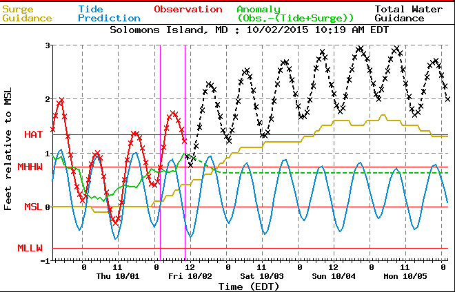
At this point, we have at least a strong probability of some severe weather on Monday. Tide are predicted to be high, up to 2.5 feet above normal:


Predictions for Joaquin are being complicated by the nor'easter that started yesterday (see that black cloud?), is winding up today with plenty of wind and rain, and is expected to peak tomorrow. By Sunday and Monday, we'll be plenty wet and wind blown, with Joaquin near the front door. Oh goody!

We have plenty of propane for the generator, so if we lose power, we can cook and keep the fish farm. I'm not expecting to have to move the boat; in the lift it should take a 3-4 ft tidal surge with no problem. But that could change.

Stay tuned.